SRTM in a tile
Retrieve SRTM tiles |
|
This service provides a TIFF image with values from the SRTM (Shuttle Radar Topography Mission) Digital Elevation Model.
Available worldwide and for free. WGS 84 projection (=constant step in latitudes and longitudes).
Command:
http://geoserver.webservice-energy.org/geoserver/mapserv/ows?SERVICE=WMS&VERSION=1.3.0&REQUEST=GetMap&
BBOX=min_lat,min_lon,max_lat,max_lon&CRS=EPSG:4326&WIDTH=nb_pix&HEIGHT=nb_pix&LAYERS=srtm&FORMAT=image/tiff
with:
- min_lon: west bound of your bbox
- max_lon: east bound of your bbox
- min_lat: south bound of your bbox
- max_lat: north bound of your bbox
- nb_pix: size of the image in pixels
Characteristics:
The webservice supplies a map of max 2048 by 2048 pixels. Where SRTM is not defined, i.e. in the water areas, value is -32768 or -2ˆ15. The highest spatial resolution is 5°/6000 pixels, which means that 1 pixel corresponds to 0.000833° (= 3" = 3*1/3600). If you request a pixel size higher than the spatial resolution, an undersampling operator is applied to create a coarser image. Whereas, if the requested pixel size is smaller than the spatial resolution, a bilinear oversampling is applied on the image.
Don't hesitate to explore the webservice-energy.org catalog.
Example
|
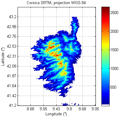
Retrieve the SRTM tile over Corsica (right illustration =>) http://geoserver.webservice-energy.org/geoserver/mapserv/ows?SERVICE=WMS&VERSION=1.3.0&REQUEST=GetMap&BBOX=41.2,8.3,43.2,9.8&CRS=EPSG:4326&WIDTH=600&HEIGHT=1000&LAYERS=srtm&FORMAT=image/tiff |
|
|
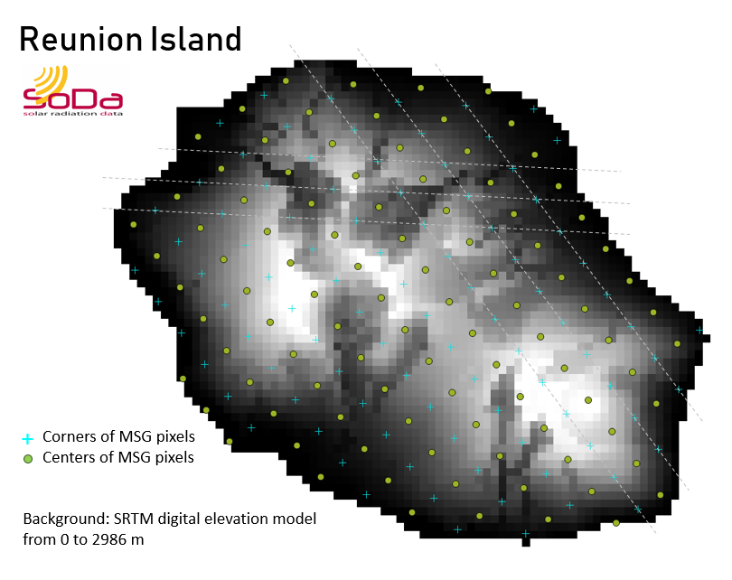
Over the reunion Island - 1 km spatial resolution: http://geoserver.webservice-energy.org/geoserver/mapserv/ows?SERVICE=WMS&VERSION=1.3.0&REQUEST=GetMap&BBOX=-22,55,-20,56&CRS=EPSG:4326&WIDTH=120&HEIGHT=240&LAYERS=srtm&FORMAT=image/tiff NB: the location of the centers and corners of the MSG pixels are overlayed on the DEM. |
 |